The shrinking of Lake Mead is more than a water story; it’s a crisis of physics where falling pressure directly translates to a critical loss of power for the American Southwest.
- Each foot of lost water level reduces the hydrostatic pressure needed to spin the turbines, cutting power output significantly from its original capacity.
- The infamous « bathtub ring » is a physical scar marking a historic loss of water volume, a direct and visible measure of the growing energy deficit.
Recommendation: Understanding the lake’s critical elevation thresholds is vital, as hitting the « dead pool » level of 895 feet would mean gravity can no longer pull water downstream, halting flow to California and Arizona entirely.
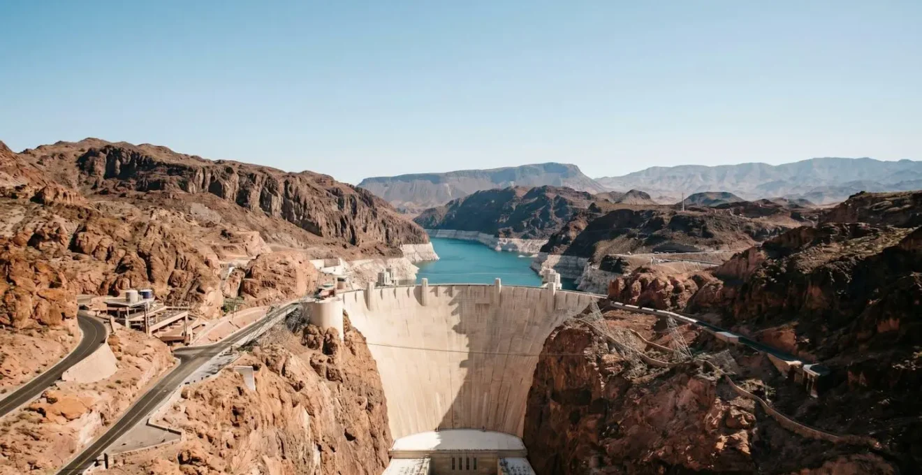
To any visitor standing at the edge of Lake Mead, the most striking feature isn’t the vast expanse of water, but the stark white stain on the canyon walls. This « bathtub ring » is a hauntingly beautiful, yet deeply alarming, geological scar. It’s the most visible symptom of a profound crisis unfolding largely unseen, deep within the concrete heart of the Hoover Dam. While most news reports focus on the drought, they often miss the fundamental point: this is a story of physics. The simple, relentless force of gravity that has powered the Southwest for nearly a century is failing.
The core of the problem is not merely a lack of water, but a loss of hydrostatic pressure. The immense weight of a full lake is what gives the Colorado River its power as it funnels through the dam’s penstocks. As the water level drops, so does the pressure, and the giant turbines begin to struggle. This article moves beyond the headlines to explain the engineering and physics of this crisis. We will explore the direct link between the bathtub ring and lost megawatts, examine the desperate engineering interventions to keep the lights on, and face the terrifying reality of what happens when a 20th-century marvel of engineering confronts the brutal reality of 21st-century climate change.
This guide will walk you through the cascading effects of the water crisis at Lake Mead, from the visible signs on the surface to the critical mechanics of power generation deep inside the dam. You will gain a clear understanding of the operational thresholds, the risks involved, and the immense efforts being made to manage an unprecedented environmental challenge.
Summary: Lake Mead Power Plant: How Does the Water Level Affect Electricity?
- Why the White « Bathtub Ring » on the Rocks is So Alarming?
- How the Turbines Spin When Water Pressure Drops?
- Hemenway Harbor vs. Callville Bay: Which Boat Ramp is Still Open?
- The Danger of Walking on Exposed Lake Beds
- What Happens if the Lake Hits « Dead Pool » Status?
- Why the 1.5 Million Gallon Pool in « O » Doesn’t Leak?
- Dam Tour vs. Power Plant Tour: Which Goes Deeper?
- Colorado River: How to Kayak the Black Canyon from Vegas?
Why the White « Bathtub Ring » on the Rocks is So Alarming?
The stark white band staining the red canyon walls around Lake Mead is far more than a simple waterline. It is a geological scar and a precise, visible record of crisis. This « bathtub ring » is composed of mineral deposits, primarily calcium carbonate, left behind as the water recedes. According to Colin Williams of the United States Geological Survey (USGS), this chalky substance is a natural component of the water flowing down the Colorado River. As the lake evaporates or is drawn down, the minerals precipitate out and bake onto the rock in the intense desert sun. The result is a stark, pale crust that clings to the rock face.

What makes this ring so alarming is its sheer scale. It represents a massive volume of lost water, a liquid asset that translates directly into electrical power and life-sustaining resources for the Southwest. At its most extreme, the top of this mineral band has towered approximately 140 feet above the current water level. This isn’t just a mark; it’s a measurement. It quantifies a deficit of trillions of gallons of water, each gallon representing stored gravitational potential energy that can no longer be converted into electricity. Every inch of that ring is a testament to diminished hydrostatic pressure and a stark warning of the dam’s dwindling capacity to perform its primary function.
How the Turbines Spin When Water Pressure Drops?
The Hoover Dam’s power generation is a marvel of simple physics: gravity pulls water from the massive height of Lake Mead through large pipes called penstocks, causing giant turbines to spin. The crucial variable is « head, » the difference in height between the lake’s surface and the turbines. A higher head means more water pressure, which spins the turbines faster and generates more electricity. Conversely, as Lake Mead’s level drops, the head decreases, the pressure weakens, and the turbines spin with less force. The result is a direct and measurable decline in power output.
The impact is not theoretical; it is a clear and present reality. At its peak capacity, with Lake Mead full, the Hoover Dam can generate 2,080 megawatts (MW) of power. Today, with the lake’s diminished state, that capacity has been slashed. A recent analysis reports the current output is closer to 1,304 MW, a loss of over 37% of its potential. This reduction in clean, hydroelectric power has significant consequences for the stability of the Western power grid, forcing utilities to rely on more expensive and carbon-intensive energy sources.
Case Study: The Proactive Installation of Low-Head Turbines
In a crucial act of foresight over a decade ago, engineers addressed the coming crisis. A $42 million project saw the installation of five specialized low-head turbines at Hoover Dam. These modern turbines are designed to operate efficiently even with significantly lower water pressure, functioning down to a lake elevation of 950 feet. This is a critical buffer, as the dam’s twelve original, older turbines must cease operation at 1,035 feet. This engineering intervention is a perfect example of adaptation, ensuring that the dam can continue to generate some power under severe drought conditions that would have silenced it entirely otherwise.
This situation represents a constant battle between 20th-century engineering designed for a wetter world and the harsh realities of 21st-century climate change. The turbines struggle to spin not because they are broken, but because the force that drives them—the immense weight of the water above—is disappearing.
Hemenway Harbor vs. Callville Bay: Which Boat Ramp is Still Open?
The shrinking lake has had a dramatic and visible impact on recreational access, particularly for boaters. Concrete boat ramps that once descended into deep water now end abruptly on dry, cracked earth. This has forced the National Park Service (NPS) into a costly and relentless battle to maintain public access. The situation at the lake’s major launch points, like Hemenway Harbor and Callville Bay, has become a moving target, with availability determined by the lake’s fluctuating level and the progress of massive extension projects.
To combat the receding shoreline, the NPS has been forced to invest heavily in extending these ramps. At Hemenway Harbor, for example, a project costing $15.7 million is underway to add new concrete lanes further into the basin. These are not simple repairs but major construction efforts, often involving earth-moving on a massive scale to chase the water. As of early 2024, temporary, pipe-mat ramps are often the only way to launch, and access can change weekly. Callville Bay faces similar challenges, with its multi-lane ramp now a fraction of its former usable length. Boaters must check the official NPS Lake Mead website for daily updates before even hitching up their trailers.
This struggle highlights the immense secondary costs of the water crisis. As Justin Pattison, the Deputy Superintendent of the recreation area, stated, the park service is committed to maintaining access wherever it is financially and logistically feasible. The constant chase, however, demonstrates the strain on resources as staff and funds are diverted to simply keeping the lake accessible, a task that was once taken for granted. The open or closed status of a boat ramp has become a real-time indicator of the lake’s health.
The Danger of Walking on Exposed Lake Beds
As Lake Mead has receded, it has exposed vast, new landscapes that were once submerged. These newly revealed shorelines, known as « bathtub rings » of a different sort, can appear inviting to hikers and explorers. However, venturing onto these exposed lake beds is extremely dangerous. The ground is a deceptive trap. A thin, sun-baked crust of dried mud and salt often covers deep, unconsolidated sediment that has the consistency of quicksand. What looks solid can give way in an instant, trapping a person up to their knees or waist in thick, sticky mud that is incredibly difficult to escape.
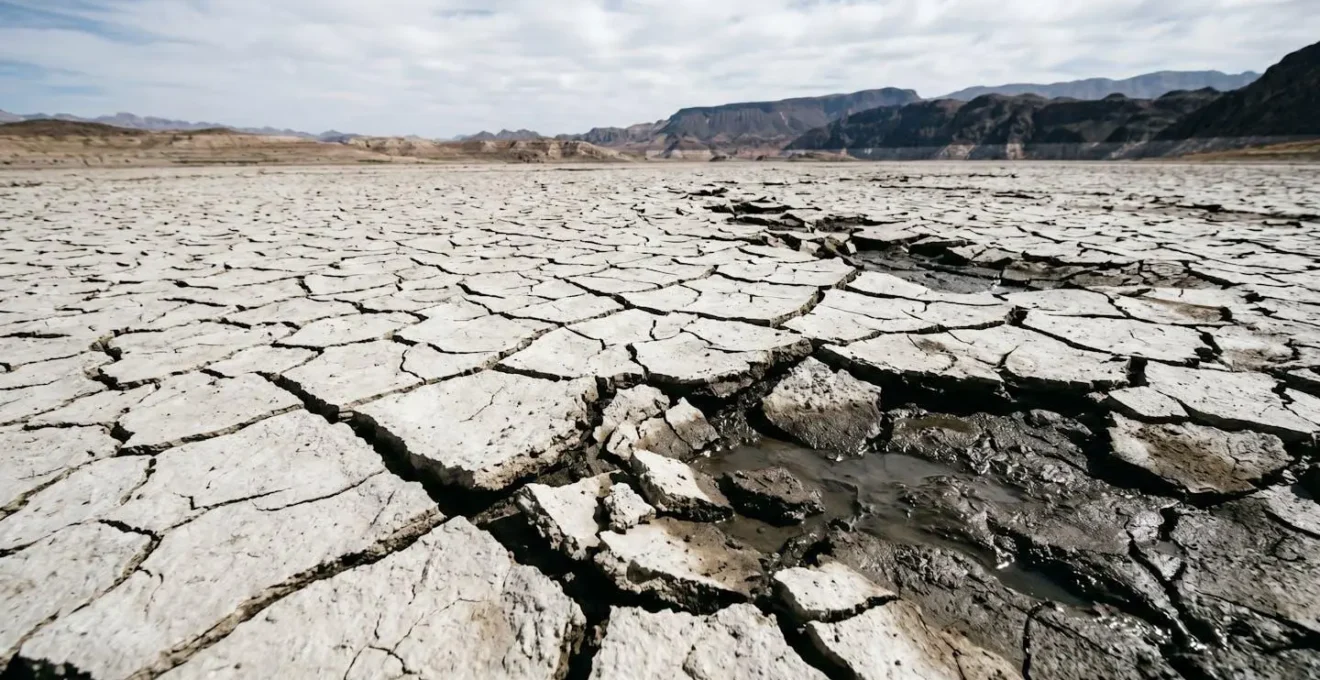
Beyond the risk of getting stuck, the terrain itself is hazardous. The new land is unstable and prone to collapse, and the rapid retreat of the water has also uncovered long-hidden objects, from old boats and debris to more recent, somber discoveries. The isolation adds another layer of danger; a simple twisted ankle can become a life-threatening emergency in the extreme desert heat with no shade or water sources readily available. Park rangers and emergency services have conducted numerous rescues of individuals who underestimated the perils of this new, alien landscape.
Action Plan: Safety Checklist for Exploring Lake Mead’s Shorelines
- Assess your supplies: Pack significantly more water and high-energy snacks than you believe you will need for your planned excursion. Dehydration is a rapid and serious threat.
- Establish a safety contact: Always hike with a companion. If you must go alone, inform a reliable person of your exact route and your expected time of return.
- Prepare for the worst-case scenario: Your pack should include essential survival items such as an emergency blanket for temperature drops, a headlamp for unexpected delays, and a wag bag for human waste to protect the fragile environment.
- Know your emergency contacts: If you are in immediate danger, dial 9-1-1. For park-specific emergencies, have the Lake Mead Dispatch number (702-293-8932) saved in your phone.
- Respect the terrain: Stay off the moist, dark sediment near the water’s edge. Stick to established trails and solid, dry ground far from the current shoreline.
The temptation to walk where a lake once was is understandable, but the risks are severe. The safest way to experience Lake Mead is from established viewpoints and designated trails, respecting the posted warnings and the raw, untamed power of the desert environment.
What Happens if the Lake Hits « Dead Pool » Status?
The term « dead pool » is not merely dramatic; it is a specific, engineering term for a catastrophic system failure. It represents the point at which the water level in Lake Mead drops so low that gravity can no longer pull water through the dam’s lowest outlets to send downstream to Arizona, California, and Mexico. This critical elevation is 895 feet above sea level. Reaching dead pool would mean the Colorado River effectively stops flowing past the Hoover Dam. While the dam would still hold a significant amount of water, it would become an « inactive » reservoir, unable to fulfill its primary function of water delivery to millions.
Even before reaching dead pool, there is another critical threshold: the minimum power pool. This is the level at which the water is too low to enter the intakes for the power-generating turbines. Thanks to the new low-head turbines, this level is currently at 950 feet. If the lake were to drop below this elevation, the Hoover Dam would cease to generate any electricity at all, transforming from a powerhouse into a silent concrete plug. These thresholds are not abstract concepts; they are the hard limits of the system’s operational design.
The following table breaks down these critical levels and their dire consequences, illustrating the cascade of failures as the water level drops.
| Elevation Level | Status | Consequences |
|---|---|---|
| 1,229 feet | Full Pool | Maximum capacity (28.23 million acre-feet) |
| 1,075 feet | Shortage Declaration Trigger | Water use restrictions for Arizona and Nevada |
| 1,050 feet | Original Minimum Power Pool | Older turbines cease operation under original design |
| 950 feet | Current Minimum Power Pool | All turbines stop generating electricity; low-head turbines operational limit |
| 895 feet | Dead Pool | Gravity cannot draw water downstream to Arizona and California |
Avoiding these outcomes is the single greatest challenge facing water managers in the American West. It requires unprecedented levels of conservation, cooperation, and innovation. As water policy expert Felicia Marcus urgently stated, « We have to get off our butts and go faster on all of it. We know what to do. We just have to turn up the volume. »
Why the 1.5 Million Gallon Pool in « O » Doesn’t Leak?
While the title might seem to refer to a specific Las Vegas show, its real significance in the context of the Lake Mead crisis is as a symbol of regional water use and conservation. The question isn’t about a single pool, but about how a city known for extravagance can exist in a desert, drawing from the same strained water source. The survival of Las Vegas and its iconic attractions is intrinsically linked to the health of the Colorado River and, by extension, the level of Lake Mead. The region’s ability to thrive hinges on a radical approach to water management.
The key is a world-renowned water recycling program. Nearly every drop of water used indoors in Southern Nevada—from sinks, showers, and toilets—is collected, treated to exacting standards, and returned to Lake Mead. This closed-loop system means that indoor water use is largely non-consumptive. This is why the Southern Nevada Water Authority (SNWA) can focus its conservation efforts almost entirely on outdoor water use, such as banning ornamental grass and enforcing strict watering schedules. It’s a sophisticated engineering solution to an existential threat.
The results of this aggressive strategy are staggering. Despite a population boom, the region has achieved a remarkable reduction in its water consumption. According to the SNWA, Southern Nevada has managed a 40 percent reduction in water use since 2002, even while its population grew by 55 percent. This achievement in conservation is a critical piece of the puzzle, buying precious time and feet of elevation for Lake Mead. It proves that large-scale human adaptation is possible and serves as a model for other arid regions facing similar crises.
Dam Tour vs. Power Plant Tour: Which Goes Deeper?
For the nearly a million people who visit Hoover Dam each year, the tours offer a rare chance to step inside this icon of American engineering. The facility offers several options, but the two main experiences are the Dam Tour and the Power Plant Tour, and the choice between them depends on how deep—both literally and figuratively—you want to go. Both tours provide a powerful, tangible connection to the power and water crisis unfolding at Lake Mead.
The Power Plant Tour is the most common option. It takes visitors via elevator 530 feet down into the rock walls of Black Canyon to see the massive penstock pipes and stand in the Nevada wing of the power plant. Here, you can look down the long gallery of massive generators, feeling the low thrum of the spinning turbines. It’s an impressive experience that directly connects you to the process of hydroelectric generation. You see the machinery at the heart of the system.
However, the Dam Tour goes deeper. It includes all elements of the Power Plant Tour but adds a crucial component: a journey into the inspection tunnels, or « adits, » that honeycomb the interior of the dam’s concrete structure. These are smaller, dimly lit passageways that were originally used to monitor the concrete as it cured. Walking through them provides an unparalleled sense of the dam’s immense scale and mass. You can feel the coolness of the concrete and see the seepage of water that naturally percolates through the structure. This tour offers a more geological and structural perspective, revealing the raw immensity of the barrier holding back the lake. For those wanting to truly understand the physical object at the center of the crisis, the Dam Tour is the one that goes deeper.
Key Takeaways
- The « bathtub ring » is a physical measurement of lost water, directly corresponding to a loss of potential energy for power generation.
- Reduced water levels lower hydrostatic pressure, forcing turbines to spin slower and drastically cutting the Hoover Dam’s electricity output.
- Critical thresholds like « minimum power pool » (950 ft) and « dead pool » (895 ft) represent hard engineering limits where power generation and then all downstream water flow would cease.
Colorado River: How to Kayak the Black Canyon from Vegas?
Kayaking the Black Canyon below the Hoover Dam offers one of the most profound and humbling perspectives on the American West’s water crisis. Paddling on the cold, clear, emerald-green water, you are floating on the very lifeblood of the Southwest. This stretch of the Colorado River, accessible only with a permit, is a place of stark contrasts: the silent, towering canyon walls, the massive, imposing concrete of the dam, and the quiet knowledge that this water is destined for the taps of nearly 20 million people across Arizona, Nevada, California, and Mexico.
To embark on this journey, you must go through a permitted outfitter. The National Park Service strictly controls access from the launch site at the base of the dam to prevent overcrowding and ensure safety. Several authorized companies based in or near Las Vegas offer guided day trips or multi-day excursions. They handle the permits, transportation from the city to the launch site, and all necessary equipment—kayaks, paddles, and life vests. A guided trip is highly recommended, as the guides provide invaluable historical and ecological context, turning a simple paddle into a deep educational experience.
The experience itself is unforgettable. You’ll paddle past historic gauging stations, explore hot springs that bubble up at the river’s edge, and witness wildlife like desert bighorn sheep navigating the steep cliffs. But most importantly, you are in the canyon, looking up at the dam and the visible « bathtub ring » on the walls of Lake Mead above it. From this vantage point, the scale of the engineering and the magnitude of the water loss are intensely personal. You are not just observing the system; you are a part of it, floating on the contested resource at the very heart of the crisis. It is a powerful, educational, and urgent reminder of what is at stake.
The evidence is clear: from the mineral stains on the rocks to the silent struggle of the turbines, the Hoover Dam is a system under immense stress. Understanding these interconnected pieces is no longer an academic exercise; it is a civic necessity. The next step is to translate this understanding into conscious action and support for policies that address this urgent, systemic fragility.